Increase revenue and enhance the patient experience by simplifying indoor & outdoor hospital navigation
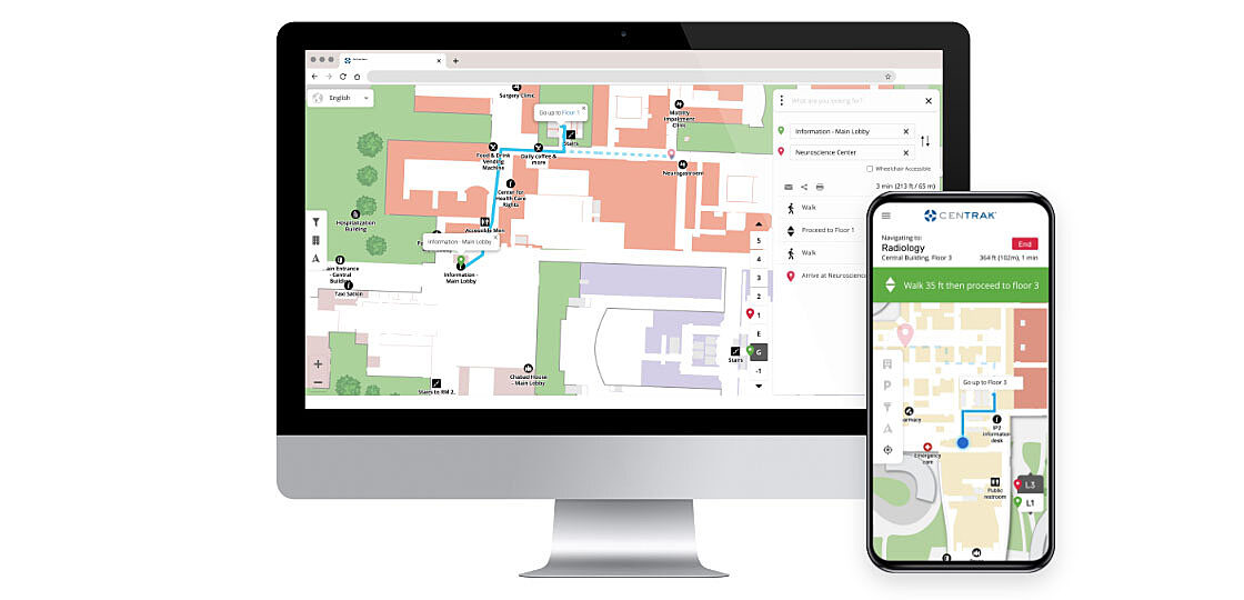
CenTrak offers a complete patient-centric solution, including EMR integrations for real-time appointment reminders with directions to the closest parking area. The solution offers turn-by-turn navigation, highlighted routes, intuitive search by keywords or points-of-interest, and custom routing such as wheelchair-accessible paths.

Don't let missed or late appointments slow you down
Hospitals lose significant revenue every year due to late or missed appointments directly related to patient confusion with parking, directions, and unrealistic time estimates. Additionally, staff members are often stopped for directions which takes time away from completing their critical tasks efficiently.
Hospital wayfinding apps, browsers, and kiosks — give patients every option to navigate your facility
Utilizing Bluetooth Low Energy (BLE), GPS, and/or Wi-Fi capabilities, CenTrak enables an enhanced patient experience with step-by-step navigation throughout their healthcare journey. Combining real-time patient wayfinding with other RTLS investments, from a single source, reduces IT burden and maximizes ROI. Alternatively, QR Code signage may be quickly deployed for wayfinding access on any browser or kiosk, eliminating the need for RTLS hardware installation and maintenance.
Digital wayfinding has elevated our patient experience initiatives and gives patients an idea of where they are going before ever stepping foot on campus.
Make your facility more accessible
Powered by Google Maps, CenTrak delivers a cost-effective, flexible and scalable mapping solution for healthcare.
An interactive hospital directory to solve your patient wayfinding pain points
Building floorplans are transformed into interactive, user-friendly maps with easy access to directories, parking areas, lists of local “near me” points of interest (POIs), and more. Patients, visitors, and staff can then use a mobile application, webpage, or dedicated kiosk for directions across campus, between buildings and floors, and back to their parking location
Campus views and individual facility maps are interactive and integrated with Google Maps for a familiar user experience.
Effortlessly keep facility maps and points of interest (POIs) up to date, and manage pathways as needed through the cloud-based CMS.
Automatically launch wayfinding & include helpful details in appt. reminders: where to park, fastest route, and time to destination.
Patients have the ability to share routes and points of interest via email or SMS with family and friends.
Reduce patient delays and wait times.
Ease anxieties while increasing HCAHPS scores.
Reduce the need for staff to provide directional assistance.
Outdoor to indoor, building to building, floor to floor wayfinding
CenTrak's digital wayfinding solution for hospitals allows for a smooth transition from home, to campus, and finally, to appointment location. Interactive outdoor and indoor maps allow users to zoom in/out, switch floor-level views, and save their parking location. Extend the solution to multiple campuses within one convenient interface.
-
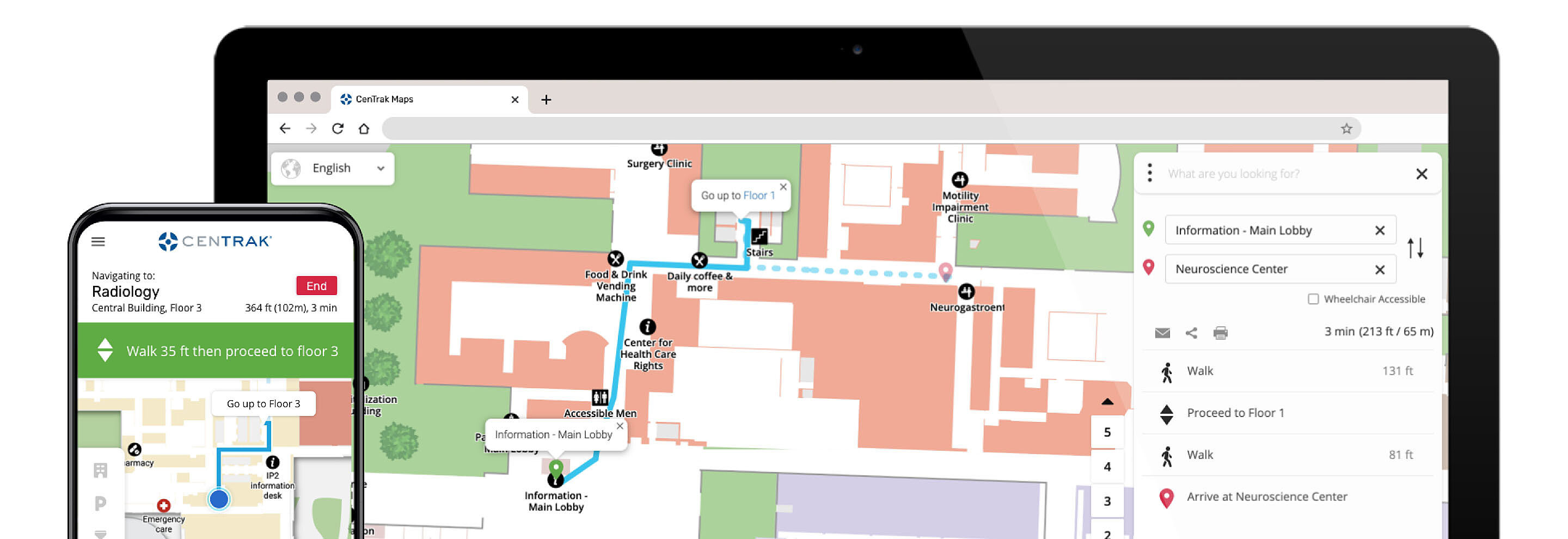
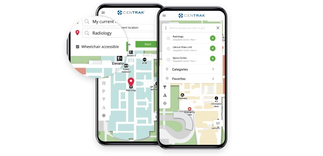
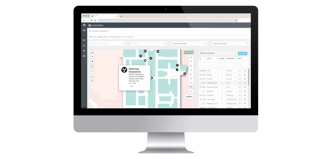
Routes and Points of Interest
![Experience - POI]()
Pathway management and informative points-of-interest
Our routing algorithm finds the shortest route to the destination and can be configured to use preferred entrances, corridors, and elevators, staff-only routes are also an option. Users may also choose accessible routes that avoid stairs, narrow corridors, or steep inclines. Patients can search for popular points of interest by name, category, or keyword. Points of Interest (POI) data can include helpful details such as:
- Contact information
- Hours of operation, keywords for smart search
- Descriptions
- Images, videos, and web URLs
-
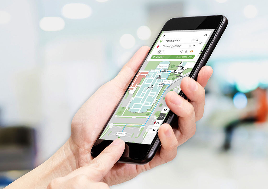
Wayfinding Mobile Applications
![Experience - Delivery Options]()
Hospital wayfinding for iOS and Android devices
Feature your site in CenTrak’s multi-tenant wayfinding application (user selects site from a list of available healthcare campuses), easily integrate CenTrak’s wayfinding module into your own mobile app, or upgrade to a custom branded / white-labeled solution.
- Real-time navigation provided by GPS technology and standalone BLE beacons
- Leverage BLE-compatible Gen2IR devices from CenTrak (Virtual Walls/Monitors) and/or compatible Wi-Fi Access Points for supplemental coverage
-
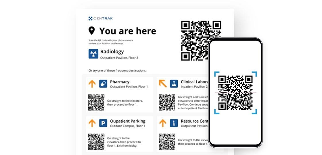
QR Code Solutions - Browsers & Kiosks
![Experience - QR Solution]()
Low-cost, big impact
CenTrak provides an economic and cost-effective wayfinding option without the need for additional hardware installation or mobile apps to download — one of the most significant barriers to user adoption. QR code signage positioned throughout the facility enables users to simply scan the code from their mobile device (connected to Wi-Fi or cellular data), choose their destination from the facility’s digital directory, and start navigating.
- Access digital hospital wayfinding via any mobile or desktop browser with the ability to download and print routes
- A unique URL can be provided or embed wayfinding maps into your existing website
- Embed wayfinding software into stationary kiosks to view directions from kiosk location to destination
- Ability to scan QR code within kiosk to transfer wayfinding to mobile device at any time
-
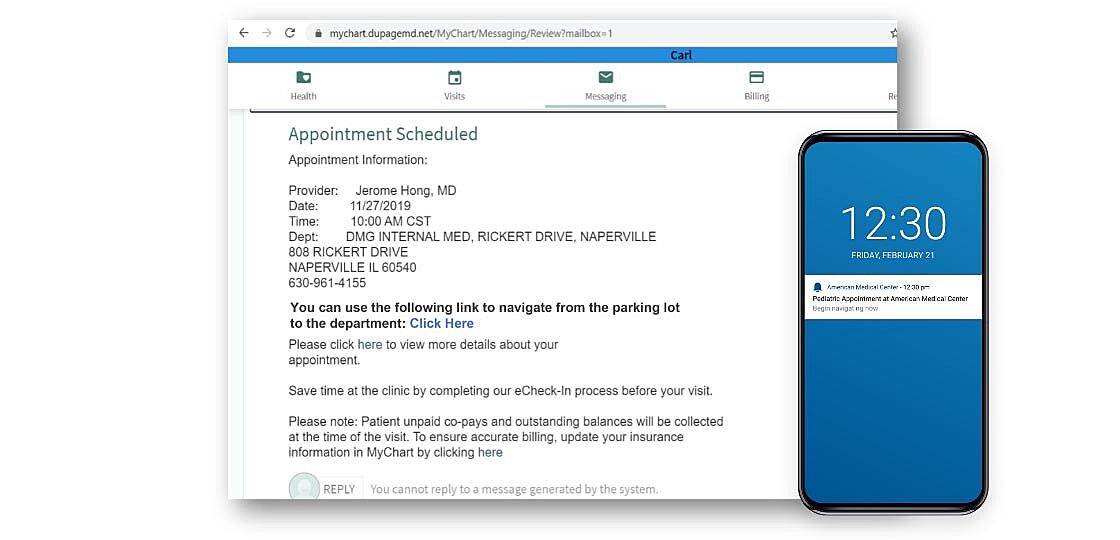
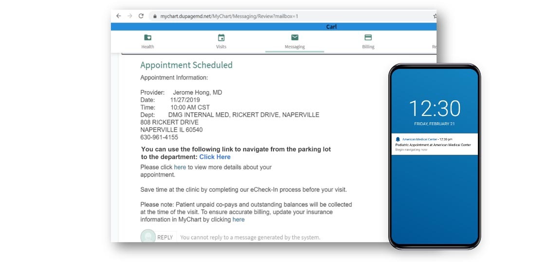
EMR Integration
![Experience - EMR]()
Provide personalized appointment information with actionable reminders
Help your patients prepare for their visits by sending helpful appointment reminders that include the route from home to the suggested parking area, as well as the duration of the walk to their final appointment destination. Navigation can be launched directly from appointment reminders.
Share points-of-interest and routes in appointment reminders via:
- Email or SMS (text messaging)
- Push notifications from hospital app
- Within patient portals such as Epic MyChart
-
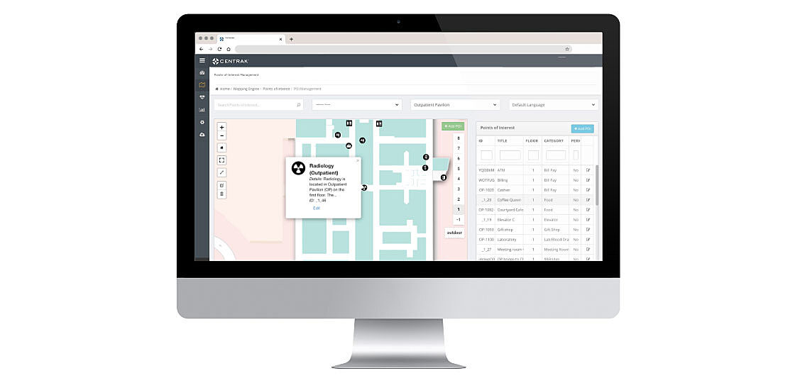
Admin Portal
![Experience - CMS]()
Creating the maps and giving your patients access to up-to-date facility information
Initially, CenTrak creates a modern, interactive hospital map from CAD or other floor plan files. As facilities change over time, CenTrak’s Wayfinding Admin Portal allows for administrative flexibility to future-proof your Wayfinding and Location Services platform. The web-based portal helps users easily create and update critical information, such as:
- Facility Maps
- Points-of-interest with metadata
- Pathways and routing
- Geofence zones
- Reports

-
Routes and Points of Interest
![Experience - POI]()
Pathway management and informative points-of-interest
Our routing algorithm finds the shortest route to the destination and can be configured to use preferred entrances, corridors, and elevators, staff-only routes are also an option. Users may also choose accessible routes that avoid stairs, narrow corridors, or steep inclines. Patients can search for popular points of interest by name, category, or keyword. Points of Interest (POI) data can include helpful details such as:
- Contact information
- Hours of operation, keywords for smart search
- Descriptions
- Images, videos, and web URLs
-
Wayfinding Mobile Applications
![Experience - Delivery Options]()
Hospital wayfinding for iOS and Android devices
Feature your site in CenTrak’s multi-tenant wayfinding application (user selects site from a list of available healthcare campuses), easily integrate CenTrak’s wayfinding module into your own mobile app, or upgrade to a custom branded / white-labeled solution.
- Real-time navigation provided by GPS technology and standalone BLE beacons
- Leverage BLE-compatible Gen2IR devices from CenTrak (Virtual Walls/Monitors) and/or compatible Wi-Fi Access Points for supplemental coverage
-
QR Code Solutions - Browsers & Kiosks
![Experience - QR Solution]()
Low-cost, big impact
CenTrak provides an economic and cost-effective wayfinding option without the need for additional hardware installation or mobile apps to download — one of the most significant barriers to user adoption. QR code signage positioned throughout the facility enables users to simply scan the code from their mobile device (connected to Wi-Fi or cellular data), choose their destination from the facility’s digital directory, and start navigating.
- Access digital hospital wayfinding via any mobile or desktop browser with the ability to download and print routes
- A unique URL can be provided or embed wayfinding maps into your existing website
- Embed wayfinding software into stationary kiosks to view directions from kiosk location to destination
- Ability to scan QR code within kiosk to transfer wayfinding to mobile device at any time
-
EMR Integration
![Experience - EMR]()
Provide personalized appointment information with actionable reminders
Help your patients prepare for their visits by sending helpful appointment reminders that include the route from home to the suggested parking area, as well as the duration of the walk to their final appointment destination. Navigation can be launched directly from appointment reminders.
Share points-of-interest and routes in appointment reminders via:
- Email or SMS (text messaging)
- Push notifications from hospital app
- Within patient portals such as Epic MyChart
-
Admin Portal
![Experience - CMS]()
Creating the maps and giving your patients access to up-to-date facility information
Initially, CenTrak creates a modern, interactive hospital map from CAD or other floor plan files. As facilities change over time, CenTrak’s Wayfinding Admin Portal allows for administrative flexibility to future-proof your Wayfinding and Location Services platform. The web-based portal helps users easily create and update critical information, such as:
- Facility Maps
- Points-of-interest with metadata
- Pathways and routing
- Geofence zones
- Reports
Pathway management and informative points-of-interest
Our routing algorithm finds the shortest route to the destination and can be configured to use preferred entrances, corridors, and elevators, staff-only routes are also an option. Users may also choose accessible routes that avoid stairs, narrow corridors, or steep inclines. Patients can search for popular points of interest by name, category, or keyword. Points of Interest (POI) data can include helpful details such as:
- Contact information
- Hours of operation, keywords for smart search
- Descriptions
- Images, videos, and web URLs

Hospital wayfinding for iOS and Android devices
Feature your site in CenTrak’s multi-tenant wayfinding application (user selects site from a list of available healthcare campuses), easily integrate CenTrak’s wayfinding module into your own mobile app, or upgrade to a custom branded / white-labeled solution.
- Real-time navigation provided by GPS technology and standalone BLE beacons
- Leverage BLE-compatible Gen2IR devices from CenTrak (Virtual Walls/Monitors) and/or compatible Wi-Fi Access Points for supplemental coverage

Low-cost, big impact
CenTrak provides an economic and cost-effective wayfinding option without the need for additional hardware installation or mobile apps to download — one of the most significant barriers to user adoption. QR code signage positioned throughout the facility enables users to simply scan the code from their mobile device (connected to Wi-Fi or cellular data), choose their destination from the facility’s digital directory, and start navigating.
- Access digital hospital wayfinding via any mobile or desktop browser with the ability to download and print routes
- A unique URL can be provided or embed wayfinding maps into your existing website
- Embed wayfinding software into stationary kiosks to view directions from kiosk location to destination
- Ability to scan QR code within kiosk to transfer wayfinding to mobile device at any time
Provide personalized appointment information with actionable reminders
Help your patients prepare for their visits by sending helpful appointment reminders that include the route from home to the suggested parking area, as well as the duration of the walk to their final appointment destination. Navigation can be launched directly from appointment reminders.
Share points-of-interest and routes in appointment reminders via:
- Email or SMS (text messaging)
- Push notifications from hospital app
- Within patient portals such as Epic MyChart
Creating the maps and giving your patients access to up-to-date facility information
Initially, CenTrak creates a modern, interactive hospital map from CAD or other floor plan files. As facilities change over time, CenTrak’s Wayfinding Admin Portal allows for administrative flexibility to future-proof your Wayfinding and Location Services platform. The web-based portal helps users easily create and update critical information, such as:
- Facility Maps
- Points-of-interest with metadata
- Pathways and routing
- Geofence zones
- Reports
What are you waiting for? Schedule a demo today.
With the industry’s most scalable and robust Real-Time Location System (RTLS), CenTrak has helped over 2,000 world-class healthcare facilities increase productivity, streamline workflows, drive higher patient and staff satisfaction, and reduce costs.